Our first visit to Africa was during our honeymoon. We did a safari in Kenya, riding in a van with 6 other tourists from one game part to another, seeing and photographing the animals and learning a little about the culture. When Hanks Aero Adventures proposed an Escorted Self-fly Safari experience, we were interested.Having an escort was desired, to provide knowledge of the area and help with the administrative complexities so we could focus on the joy of flying in southern Africa. Much of our time was spent in the wonderful lodges and camps that were arranged by Nick and Christina Hanks for our trip, but this post will focus on the flying.
A pilot needs to get their license "validated" before being permitted to fly a South African registered aircraft. The validation process started months before the safari in South Africa. I had fill out a 1 page validation application and send notarized copies of my American pilot's license, medical, recent logbook pages and passport photos to Hanks Aero Adventures. They took care of all of the details. Validation is for a specific model of airplane. Hanks Aero Adventures uses Cessna 182s. During the months before the safari, I found a Cessna 182 at 82J for checkout and renting.It didn't hurt to do several soft field landings. 5/7/16: Arrival in South Africa
After sunrise, our Delta flight took us over Namibia so we could see the terrain where we’ll be flying. From high up, we could see the sands along the coast, the mountains, and the desert bush lands. After arrival at Johannesburg’s O. R. Tambo Airport (FAOR), the Hanks had arranged for the 45 minute drive north to the Hertford Hotel in Lanseria. At the hotel, we had are first meeting with Nick and Christina Hanks and with the crew of the other Cessna 182, Andy and Karie Davidson.
5/8/16: Lanseria Tower Briefing
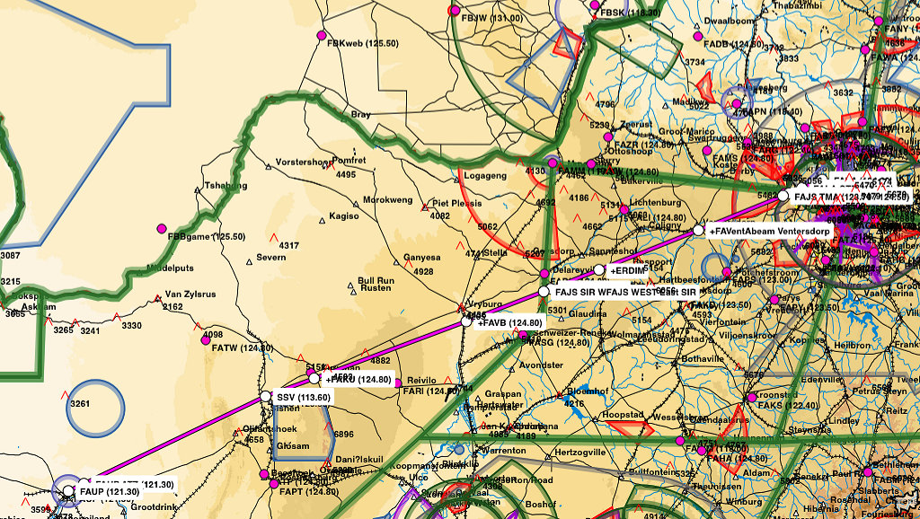
Easy Cockpit map of area around FALA
At 300 PM in the hotel, Andre from the Lanseria Airport (FALA) control tower gave us a briefing on the airport procedures and surrounding Johannesburg African airspace. There were a lot of airspace considerations for getting in and out of Lanseria Airport and some different terminology to become familiar with. Special rules, circuits, zone or boundary out were just a few in addition to the South African accent of the controllers. Airspace around Lansera is cramped. Lanseria Airport is 4521 elevation with a circuit pattern of 5500 feet. Johannesburg approach control does not allow VFR flights into the Johannesburg TMA which is 7600 feet to FL 110. There is also Lanseria CTR from ground to 6500 feet and a larger Lanseria TMA from 6500 to 7600 feet extending to the west and south of the airport. Fortunately, the tripkits from Hanks Aero had information about the altitudes to use getting in and out of Lanseria airspace. Louis Ashpole gave us a portable GPS with all of the safari flight plans to use in the Cessna 182 we would fly. After the briefing, I had to do a new flight plan for the validation flight, to take into account what I had just learned about the reporting points for the north departure from Lanseria Airport.
5/9/16: Validation Flight
At Lanseria Airport, Silke gave Liz and I a briefing on flying the South Africa bush. Silke was an instructor and a recently certified air transport pilot. She gave use many interesting and scary tips. One tip was to watch out for bush pigs and other animals who may choose to scamper onto the landing strip when the airplane is on final approach at an unsecured airport. Most bush camps send out a Land Rover with staff to clear the landing strip. But when that does not happen, or if we make a diversion to another bush strip for an unscheduled landing, we were told to overfly the landing strip at 300 feet above the ground with a wing low to inspect for animals.
We were told that danger also lurks high in the air. Large birds can fly at 2000 feet or more above ground level, circling the thermals, with no respect for loud flying machines. Birds rarely fly alone, so if one bird is seen, there will be other birds nearby. We were told to turn away and give the birds a wide birth. The birds are not afraid and act like they believe the airspace belongs to them. If a bird was aiming for a head-on collision, we were told to nose up so the bird will hit the underbelly of the airplane instead of breaking through the windshield. A nose up stall is an easy matter to recover from compared to a serious bird strike. Silke said what is more likely is that the bird will say, “oh my God!” then pull in its wings and drop out of the way. Louis, who also is an instructor, frowned on a maneuver that would result in a stall, he said just turn away from the bird.
Another worry is that night comes quickly in South Africa. There is nothing gradual about sunset; it gets dark 15 minutes after sundown. It was best to plan flights to be completed 3 hours before sunset, otherwise there is the risk for an unscheduled division to another airport.
The briefing was followed by an educational check-ride to test my piloting ability and to learn the airspace around Lanseria Airport. We pulled ZS-WAT out of the hanger, and I did a careful check to get to know this Cessna 182 that I would be flying for the next 17 days. The only minor problem was excessive static on the #2 radio, so that radio would be off and used only as a backup. After start-up, Silke and I told the controllers we would “route to Pilanesberg“ Airport. During the pre-flight run up, we did an aggressive leaning, pulling the mixture until the engine ran rough, then back to smooth which was peak power, then 3 turns of the mixture control rich of peak. This gave the best power for take-off at the high altitude Lanseria Airport. We took off on runway 07 and turned left for a northbound departure to the UTRUK intersection. I talked with Lanseria Tower until “zone out,” then with anyone who was listening in Special Rules Traffic, giving my position reports for Palindaba Power Station, the south shore of the lake made by the dam, and when over the Harteesport Dam.
At UTRUK intersection, we turned northwest to Pilanesburg Airport, set the altimeter to 1013 hPa for standard flight levels, and contacted Johannesburg Information for flight following. In South Africa, a local altimeter setting is used for flight less than 2000 feet above ground level. When the local altimeter setting is used, altitude is reported in feet above sea level. At and above 2000 feet above ground level, the standard altimeter setting is used and attitude is reported in flight levels. Johannesburg Information had a weak signal on the radio, and I could not make out what the controller was saying. Fortunately, Silke understood and she handled the radio, arranging a climb to flight level 085 (about 8500 feet above sea level or 4000 feet above ground level), then for a diversion on the route to Pilanesberg. Silke asked me to demonstrate a precautionary touch and go landing at Rustenburg Airport, then over to the practice area for an approach stall, demonstration of engine failure procedures, and a go-around over an empty field. We routed back to Lanseria Airport, contacted the tower, reported abeam the satellite tracking station, and requested to join the circuit for landing. We were told the join for a left base to runway 07, report final, and I did another touch and go landing. Then right traffic for the third landing. My first flight in another country was 1.8 hours, and Silke wrote “validation successful” in my log book was written to allow me to be pilot-in-command of a South African Cessna 182.
5/10/16: Safari Briefing
Forflight map of actual route taken on the flying safari
Nick and Chris Hanks live in the middle of a game preserve. We drove a long, bumpy dirt road to get there. At their house, we were given lunch and an extensive briefing for the entire trip. Each aircraft would have a milk crate full of supplies, including a first aid kit, survival kit, water, 2 quarts of oil and a funnel. Unless arrangements are made well ahead of time, most airfields might not have fuel. It's Africa and it's best to be prepared for anything and everything. Two airplanes got a DeLorme satellite text and GPS device so the Hanks could track our flights from their home. Nick thoughtfully included a pint of Jack Daniels whiskey to be used only if there was an emergency landing somewhere in the bush. We were also given a binder containing envelopes with complete information about each leg of the trip. These “tripkits” included runway information, altitudes, frequencies for the departure and destination airports, route information, frequencies, and alternate airports, as well as a route map and an overhead of the airports from Google Earth. We were also briefed on numerous possible emergencies and inconveniences that could occur on the safari.
After returning to the Hartford Hotel, we walked out of the south gate to a strip shopping center to get water and cookies from the supermarket and Rands from the ATM.
5/11/16: Into the bush
Launch day arrived! At Lanseria Airport (FALA), we pulled the Cessna 182 airplanes out of the hangers and the fuel truck topped them off with avgas. Supplies and luggage were loaded, headsets were plugged in, and a portable GPS and iPad mini with flight plans were clamped to the yolks. A pre-flight briefing was given. In South Africa, flight plans are required for VFR flights to and from towered airports. Flight plans for any VFR flight helps with rescue when the aircraft does not arrive at its destination. Also, pilots flying visually are supposed to maintain radio contact and give position reports to air traffic controllers along the way. Ready to go, we found ourselves delayed by a runway closure when a small
airplane landed without lowering the gear. This closed the airport to all
traffic in and out until the runway was cleared. Our planned takeoff time came
at 11:00 am and
went. We were a bit worried that if our departure was delayed too long, we would
be arriving after sunset at 5:55 pm in Upington. But, it's Africa. No use
getting upset, be patient with a smile. The commercial traffic would get to land
and depart before we would be permitted to leave.
Leg 1- FALA to FAUP
Launch for first leg of the safari finally occurred around noon. Our escorts, Louis and Shana Ashpole in their Cessna 210, ZS-LPB, were followed by the Davidsons in their Cessna 182, ZS-IWP, then my 182, ZS-WAT. All took off, flew west to the Tracking Station, then southwest at flight level 075 to Upington. Skies had scattered high clouds and 50 mile visibility. For VFR navigation, we were using the Easy Cockpit app on our iPad minis. The flight plans Louis loaded depicted our route, and Easy Cockpit displayed the radio frequencies, and showed our location with a moving airplane icon. The controllers always asked for estimates of the time arriving at certain reporting points, which was easily obtained from the Flight Log screen. During the flight, we saw farmland gradually change into ranch land, and finally there was nothing but semi-arid desert. I had difficulty hearing the FIR controller, so Louis told me to “go to numbers,” that is, frequency 123.45, so he could relay what I needed to tell the controller. The flight itself was a little over 4 hours long due to 20 knot headwinds. Cookies and bottled water came in very handy after flying 2 ½ hours. During the last 40 minutes, we followed the reflection of the sun off of the Davidson's airplane. They had radioed their position about 10 miles ahead of us. We flew over some low mountain ranges before reaching the Upington airport boundary. After contacted the tower and heard the Davidsons reporting turning final, yet we still saw the reflection off of their airplane straight ahead of us. We later found out that the reflection was not their airplane, it was actually a solar tower. The airport blended into the sand. It was when the tower told us to turn downwind that we said ourselves, "there's the airport!" After landing at Upington Airport (FAUP), we were picked up and stayed at Bain's House for the night.
5/12/16: Crossing the border
Today’s flight involved crossing an international border and dealing with government employees. For this reason, we both wore pilot uniforms which consisted of a white pilot shirt with epaulettes on the shoulders. The commercial pilots of the King Airs, Caravans, and other turboprop airplanes used for air taxi all wore pilot uniforms with epaulettes. The airport staff expected flight crews to be wearing uniforms, and the uniforms allowed for easy access to the flight apron and the airplanes. We ordered the shirts and epaulettes from mypilotstore.com. We wore navy epaulettes with 3 gold bars. I ruined the effect by wearing jeans, but Liz looked quite professional in black slacks.
Avgas in a barrel being hand pumped into wing at Keetmanshoop Airport.
After returning to Upington Airport (FAUP), we found that we would have to have our luggage checked to get back to our airplanes. We also had to go to the immigration office to fill out forms and have our passports stamped before they would fuel our airplanes. Takeoff for leg #2 was easy enough, but we found ourselves dodging rain storms.
Leg 2 - FAUP to FYKT
We deviated 20 miles off course to avoid the bad weather. Headwinds made the flight take even longer. Louis contacted Windhoek Area South with the number that Nick Hanks previously obtained permission to fly over and land in Namibia. We each had a copy of the Namibia application for overflight and landing authorization on board. We flew in a loose formation with the Davidsons in sight until landing in Keetmanshoop, Namibia. Total flight time was about 2 hours, 20 minutes. Although this was an international airport, there was nobody in the control tower there. Louis said the controller might not have come to work. Yes, it's Africa! Louis tried to land on the long asphalt runway, but he had too much of a crosswind. We all landed on the shorter gravel runway.
Leg 3 - FYKT to FYKC
After parking at Keetmanshoop International Airport (FTKT), we went inside to the customs window to fill out immigration forms and get our passports stamped with a Namibian tourist visa. Then, customs staff inspected our luggage, opening each of our duffel bags. I had to tell the customs women about the purpose of every prescription bottle. Another man had a checklist to inspect all of my pilot documents, the aircraft documents, and the airframe. Then, the customs and airplane inspectors abruptly left. Louis said it was lunch time. Two men rolled over a 200 liter drum of 100 LL aviation fuel and used a fuel pump to add avgas to our tanks. I started my engine with 200 liters, or 4 hours of fuel.
As we flew southward on leg #3, we could see the narrow Fish River growing into a vast series of increasingly larger canyons. It was a marvelous sight. We flew turning with the
Fish River Canyon
river until we reached a vast canyon complex. There were thick overhead clouds and thundershowers were about 50 miles to the west, but visibility was excellent. We made our way to Karios Airstrip (FYKC), which was a single runway of packed sand. Louis landed first and radioed that there were animals crossing the runway. The Davidsons landed next, and when Karie announced short final, I flew to the airstrip, announcing my position several times adding, “looking for animals.” The others were off their radios, so there was no answer. I over flew the airport then set up for landing, flying a steep final so we could make sure the runway was clear, before landing on the packed dirt. Flight time was 1 hour. That night we stayed at Canon Lodge.
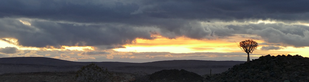
Sunset at Fish River Canyon
5/13/16: Reroute
Leg 4 - FYKC to FYKT
At the breakfast buffet, we talked about Luderitz Airport being fogged in. Our validation was for VFR, and Luderitz Airport did not have an instrument approach. Louis checked the weather repeatedly, and we waited for the clouds to lift at our destination. Two hours later, the weather did not improve for Luderotz. It
looked like we would miss out on flying up the Skeleton Coast of Namibia. Nick Hanks
called back and said arranged for more fuel to be available at Keetmanshoop. By the time we reached Karios airstrip, the winds had picked up considerably. The 15 to 20 knot winds made pre-flight and loading challenging, and the co-pilot’s door on the Davidsons’ 182 became damaged from a wind gust blowing it open. The back-taxi down the runway was a little harrowing because of the wind, but the takeoff for leg #4 occurred quickly with the headwind. The sky was clear with unlimited visibility. We flew 30 minutes back to Keetmanshoop Airport (FYKT), which was again uncontrolled. We waited for our fuel guys to arrive, roll 3 barrels of 200 liter avgas to the airplanes, and hand pump the fuel to top off our tanks.
Leg 5 - FYKT to FYGK
Airborne again for leg #5, we routed north to Geluk airstrip (FYKT). Skies remained clear with unlimited visibility. For Liz and I, our CRM, Cockpit Crew Management, was coming together nicely. I flew the airplane and checked the Easy Cockpit on the iPad for navigation. Liz fed me information from the Tripkit and monitored the display on the portable GPS. We both listened to radio transmissions and often compared what we heard with each other before responding. At 1 hour before the estimated time of arrival, we would brief the landing information in detail. Liz would recite the runway direction, altitude, length, and composition, the circuit altitude, surrounding obstacles, and the radio frequency. We looked at runway diagrams, determined what we would expect to see on the approach, and planned the descent profile. This planning helped us avoid surprises and last minute searches for information, resulting in relaxed, predictable, and safe landings.
Andy Davidson's cool photo of my landing at Geluk Airstrip
At Geluk the airstrip blended in with the surrounding terrain, and was difficult to see until we were upon it. We were able to confirm that it was the correct landing strip by seeing the other 2 airplanes in our group on the ground. The standard VFR approach to uncontrolled airports in South Africa and Namibia is to over fly the airport at 2000 feet above ground level to look for traffic in the circuit and check the safety of the runway. Then enter the downwind while descending to the traffic pattern altitude, typically 1000 feet above ground level. While circling the landing strip and while on final, the runway should be checked to make sure it is cleared of animals and other debris. We reported positions in the circuit on 124.8, the Common Traffic Advisory Frequency for all of Namibia. As we landed on the gravel strip, we could see the red sand dunes. Flight time was 1 hour 35 minutes. 5/14/16: Sossusvlei
Dune 42
We stayed at Little Kulala Lodge, part of Wilderness Safaris. The attraction there was the orange dunes of Sossusvlei in the Namib sand sea. One thing we learned is that most of the lodges had laundry service included, so 5 days of clothing should be sufficient for the trip.
5/15/16: Over the coastal mountains
Leg 6 - FYGK to FYDN
After breakfast, we arrived at the Geluk airstrip (FYGK) where the wind was 20 knots with dusty, sandy gusts. We each had been given a bagged lunch with a yummy sandwich, cookies, a drink, and water. Most of the lodges gave us lunches to take on our flights, and this made the flying more enjoyable. Our original plan that day was to refuel at Swakopmund Airport with sand/gravel runways, a part-time control tower, and avgas fuel pumps. Much of the Atlantic coast of Namibia, including Swakopmund, was still fogged in. From Lanseria, Nick Hanks check our second stop, Dora Nowas, and found they had plenty of avgas. This changed the fuel situation because we now had a 2.5 hour flight ahead. Although there were plenty of bush strips, since most lodges have one, there were very few places had had avgas. Availability of avgas had to be arranged well in advance. In flight, a Cessna 182 burns 13 gallons or 50 liters per hour. I had 180 liters in the tanks, enough for the flight to Dora Nowas (FYDN) with1 hour reserve.
Brandberg Mountain
Louis gave directions about holding the aircraft nose down during back taxi in the wind. Takeoff for leg #6 was surprisingly uneventful and we headed for Dora Nowas. Louis later told me that it looked like I did a short field takeoff, although I actually did a gusty wind takeoff where I delayed rotation until enough speed built up to overcome gusts and the airplane refused to stay on the ground. Flight conditions were clear and visibility good, except as we passed abeam of Walvis Bay, we could see the fog and low clouds hugging the coast for several miles inland. Our course to Dora Nowas would take us over Brandberg Mountain, a problem because it was higher than out planned flying altitude of flight level 085. We flew past the western slope of the mountain, missing a view of an old airplane wreck on the eastern side. Flight time was 2 hours, 35 minutes.
Fuel pump at Dora Nowas
We landed at Dora Nowas, which is a gravel strip used as a fuel stop by bush pilots in northern Namibia. We found out that Wilderness Safari supplies fuel to the airport for their Cessna Caravans. With full tanks, we departed for leg #7, into good weather with some scattered clouds above our flight level. This was a fuel critical leg with best economy leaning because there was 4 hours of flying until the next available fuel. We flew over rocky, mountainous, desolate terrain which showed me just how dangerous this flying really was. An engine failure would be fatal because there would be no suitable place to safely land. At this point, with Liz at the controls, I accidentally knocked open the pilot’s window twice while taking photos of the terrain. Liz became upset, worried about safety, and wanted to return the controls. This led to a little cockpit argument, but we calmed and resume our duties, with myself as the pilot in command and Liz as the crew.
Leg 7 - FYDN to FYHV
After flying 2 hours 10 minutes, we landed at Hartman Valley airstrip (FYHV). This strip also blended with the surrounding terrain in the valley, which all appeared off-white from 2000 feet above ground level. When Easy Cockpit on the iPad showed our airplane over the strip, we looked down and saw the other airplanes in our group. There is no information about weather or altimeter settings at most of the bush strips. The bush pilots keep their altimeters on the standard setting and report their position using flight levels. This makes it easier for the pilots of 2 different airplanes on approach to the same airport to keep track of each other’s position.
Himba villiage near Serra Cafema
5/16/16 & 5/17/16: Hartman Valley
We stayed at Serra Cafema, part of Wilderness Safari, located on the Kunene River in the remote northwest corner of Namibia. There, we visited a Himba village.
5/18/16: Flying inland
Leg 8 - FTHV to FYOA
Approach to Ongava on the other
side of the large Etosha salt pan
Leg 9 - FYOA to FYNG
Leg #8 was a 2 hour flight direct to Ondangwa Airport (FYOA), a tower controlled approach and field. The tripkit warned us that this was a fuel critical leg. We leaned the mixture for the best fuel economy, and carefully maintained course while watching the fuel consumption. The Ondangwa tower controller talked fast with a thick accent and we both had to listen to interpret his clearance. Landing on the asphalt runway was uneventful, and we topped off the airplane with fuel. The next flight, leg #9, was one hour to the Ongava landing strip (FYNG), a nice calcrete runway. We had been warned not to overfly the Etosha Pan below 7000 feet MSL on the way in, as this was policed and enforced.
5/19/16: Etosha
We stayed at the Ongava Tented Camp. There were so many animals to see in the Ongava Game Reserve and the Etosha National Park.
5/20/16: Windhoek
:Leg 10 - FYNG to FYWE
Flight Folio after Windhoek Eros
The flight for leg #10 from Ongava to Windhoek Eros Airport (FYWE) required more preparation because Windhoek was a complicated airspace with several frequency changes needed.Flight uniforms were worn because Eros was a busy, well secured airport. I was the first in the air and I opened the flight plans for all 3 airplanes with Windhoek Area North.We had clear skies and unlimited visibility for the
1 hour 45 minute flight. Approach involved position reporting inFYD-130, the Windhoek Flying Training Area, and contacting Windhoek Approach. Eros was a busy tower controlled airport. The Windhoek-Eros aerodrome diagram is available by searching for “FYWE airport aerodrome.. After landing, fuel trucks topped off our tanks and the fuel uptake was recorded in the flight folio. We ate lunch at the Skyview Restaurant in the airport terminal, a nice break.
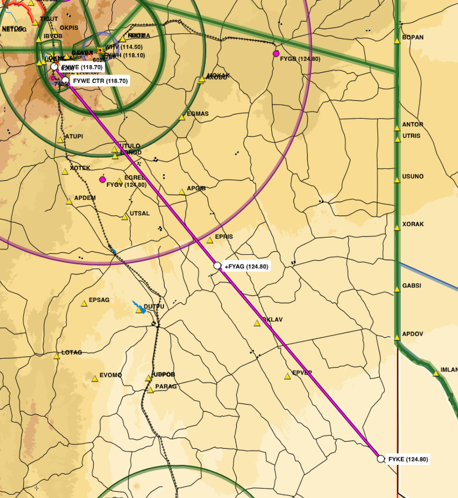
Landing at FYKE, a 40 foot wide bush strip. The flight for leg #11 from Eros to Kalahari Game Reserve (FYKE) required a rapid climb to get over the U-shaped mountains that surrounded Windhoek to the east, south, and west.
Leg 11 - FYWE to FYKE
Weather continued to be clear with unlimited visibility on the 2 hour 20 minute flight. The landing was landing because the gravel, sand and grass landing strip at the Kalahari Game Reserve only was only 40 feet wide. It was the most bushy of all the bush air strips, requiring a high altitude, soft field and precision short field landing techniques. No one had landed at this strip for the previous 6 months.
Lion at the Kalahari Game Reserve
5/21/16: Kalahari
We stayed at the Kalahari Game Lodge, and saw the animals in the Kalahari Game Reserve
5/22/16: Crossing the border again
Customs at Keetmanshoop
Leg 12 - FYKE to FYKT
This was another flight uniform day with landings at 2 international airports. Louis rechecked my oil for me. It was important to keep the airplane level as possible when checking oil, and we added another quart. We used the oil valve that I brought with me from the States. Louis liked it and I gave it to him. Even thought this was a day with 3 flights with at least 1 hour stops at 2 international airports, we had to leave a lot later than we would have liked. We were told not to arrive in Keetmanshoop Airport before 11 am because everyone in Keetmanshoop goes to church on Sunday morning. Well, it's Africa! Things are not always as expected, resources may not be available. Patience is required, good humor is helpful, and being prepared for anything is a necessity. It's Africa! We departed Kalahari Game Lodge on leg #12 and flew 1 hour under clear skies to Keetmanshoop Airport (FYKT). Again, this international airport had no tower controller. After landing, we met with
customs for an exit stamp for our passport out of Namibia. I was asked, "What
are you taking out of Namibia?" I told the customs agent some carvings and little
baskets. She seemed satisfied. After a little wait, we got extra
fuel hand pumped in from a barrel.
Our 3 airplanes tied down at Ongava airstrip
Leg 13 - FYKT to FAUP
Leg 14 - FAUP to FATW
We then flew a 1 hour 40 minute hour leg #13 in clear skies over the border to Upington Airport (FAUP). Before we could exit the airplane they sprayed the interior with disinfectant. We had to check with customs and get another tourist visa stamped into our passports for entry back into South Africa. We were then permitted to top off our tanks with fuel. A third 40 minute leg #14, again in clear skies, was flown to Tswalu Airport (FATW) which featured a paved, asphalt runway. We arrived at 400 pm, about an hour before sunset.
Cheetah at Twalu
Meerkat at Tswalu
5/23/16 and 5/24/16: Tswalu
We stayed at the Motse Lodge. We tracked cheetah and saw many other animals at the Tswalu Reserves.
5/25/16: Return to Lanseria
Landing at FALA, check out the South African accents!
Leg 15 - FATW to FALA
FALA arrival path (yellow)
Leg #15 back to Lanseria was a 2 hour 50 minute under large scattered closed at flight level 090. The flight was bumpy, but otherwise uneventful. I felt good about my radio work with Johannesburg Information. After announcing my position on Johannesburg West Special Rules, I contacted Lanseria tower and reported the tracking station, requesting joining and landing. Lanseria tower told me to not enter the control zone, so I used the VFR approach procedure into Lanseria that Silke had briefed me on. This involved a left turn after the tracking station toward the Pelindaba nuclear power station until called. Tower called me to join the circuit on a left downwind for runway 07, then cleared us for landing. Nick and Chris Hanks were waiting at the fueling bay and the airplanes were refueled. The last entries were made in the flight folio and the reliable Cessna 182 that we had flown for the past 30 hours was put back in the hanger.
We stayed at the Southern Sun Montecasino in Fourways, where we had dinner and a final debrief discussion of the trip with the Hank's and other flight crews. Altogether, we had spent 15 days in the bush, flying through 2 countries to 6 destinations. We made 15 flights totally over 2,900 nautical miles and 30.6 Hobbs hours.
Very good and informative post with beautiful images. I really enjoy reading this post a lot. You have done really great job by sharing such post. We deals with overflight and landing permit services in India. For more informative you can visit to our website. Thanks


Very good and informative post with beautiful images. I really enjoy reading this post a lot. You have done really great job by sharing such post. We deals with overflight and landing permit services in India. For more informative you can visit to our website. Thanks
ReplyDelete